![](/images/other/stat-length.png)
![Randonnée A pied Neunburg vorm Wald - R 12 (Eixendorfer Stausee) - Photo](https://media.geolcdn.com/t/1900/400/ext.pjpeg?maxdim=2&url=https%3A%2F%2Fstatic1.geolcdn.com%2Fsiteimages%2Fupload%2Ffiles%2F1545311037marcheuse_200dpi.jpg)
R 12 (Eixendorfer Stausee)
SityTrail - itinéraires balisés pédestres
Tous les sentiers balisés d’Europe GUIDE+
![Longueur](/images/other/stat-length.png)
Longueur
6,4 km
![Altitude max](https://static1.geolcdn.com/siteimages/upload/files/1508320355ic_sort_altitude_max_24dp.png)
Altitude max
473 m
![Dénivelé positif](https://static1.geolcdn.com/siteimages/upload/files/1508320355ic_sort_den_pos_24dp.png)
Dénivelé positif
128 m
![Km-Effort](/images/other/stat-length.png)
Km-Effort
8,1 km
![Altitude min](https://static1.geolcdn.com/siteimages/upload/files/1508320355ic_sort_altitude_min_24dp.png)
Altitude min
436 m
![Dénivelé négatif](https://static1.geolcdn.com/siteimages/upload/files/1508320355ic_sort_den_neg_24dp.png)
Dénivelé négatif
118 m
![Boucle](https://static1.geolcdn.com/siteimages/upload/files/16400158638029165_repeat_loop_refresh_sync_direction_icon.png)
Boucle
Non
Balise
Date de création :
2022-02-11 14:01:34.0
Dernière modification :
2022-02-11 14:01:34.0
![A pied](https://static1.geolcdn.com/sitytour/trail-icons/100.png)
1h50
Difficulté : Facile
![Scannez ce code QR pour ouvrir la randonnée dans l'application SityTrail](https://capi.geolives.com/qq0zvz2zws4bq2lad0pu/sitytour/trails/3091792/qr.png?size=200)
Application GPS de randonnée GRATUITE
À propos
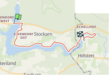
Randonnée A pied de 6,4 km à découvrir à Bavière, Landkreis Schwandorf, Neunburg vorm Wald. Cette randonnée est proposée par SityTrail - itinéraires balisés pédestres.
Description
Randonnée créée par Stadt Rötz.
Symbole: rechteckig, Querbalken oben weiß unten rot mit schwarzer Schrift R 12
Localisation
Pays :
Allemagne
Région :
Bavière
Département/Province :
Landkreis Schwandorf
Commune :
Neunburg vorm Wald
Localité :
Unknown
Départ:(Dec)
Départ:(UTM)
314502 ; 5469475 (33U) N.
Commentaires
Randonnées à proximité
![Randonnée A pied Thanstein - Kaisereichenweg - Photo](https://media.geolcdn.com/t/375/260/cda28eb4-819a-4750-a893-aa0bfcb85ab1.jpeg&format=jpg&maxdim=2)
![A pied A pied](https://static1.geolcdn.com/sitytour/trail-icons/100.png)
Kaisereichenweg
A pied
Facile
Thanstein,
Bavière,
Landkreis Schwandorf,
Allemagne
![](/images/other/stat-length.png)
5,4 km | 7,3 km-effort
1h 39min
![](https://static1.geolcdn.com/siteimages/upload/files/16400158638029165_repeat_loop_refresh_sync_direction_icon.png)
Non
![Randonnée A pied Neunburg vorm Wald - Schwarzwihrbergweg - Photo](https://media.geolcdn.com/t/375/260/eb056ad9-ae63-4485-bc2a-42f9b604a256.jpeg&format=jpg&maxdim=2)
![A pied A pied](https://static1.geolcdn.com/sitytour/trail-icons/100.png)
Schwarzwihrbergweg
A pied
Moyen
Neunburg vorm Wald,
Bavière,
Landkreis Schwandorf,
Allemagne
![](/images/other/stat-length.png)
19,9 km | 26 km-effort
6h 0min
![](https://static1.geolcdn.com/siteimages/upload/files/16400158638029165_repeat_loop_refresh_sync_direction_icon.png)
Non
![Randonnée A pied Neunburg vorm Wald - Neunburger Wanderweg - Photo](https://media.geolcdn.com/t/375/260/eb056ad9-ae63-4485-bc2a-42f9b604a256.jpeg&format=jpg&maxdim=2)
![A pied A pied](https://static1.geolcdn.com/sitytour/trail-icons/100.png)
Neunburger Wanderweg
A pied
Facile
Neunburg vorm Wald,
Bavière,
Landkreis Schwandorf,
Allemagne
![](/images/other/stat-length.png)
7 km | 7,9 km-effort
1h 48min
![](https://static1.geolcdn.com/siteimages/upload/files/16400158638029165_repeat_loop_refresh_sync_direction_icon.png)
Non
![Randonnée A pied Rötz - Bauhof-Thanstein-Weg](https://media.geolcdn.com/t/375/260/1b793e07-7979-45a2-b2ee-2247369056e3.jpeg&format=jpg&maxdim=2)
![A pied A pied](https://static1.geolcdn.com/sitytour/trail-icons/100.png)
Bauhof-Thanstein-Weg "T 4"
A pied
Facile
Rötz,
Bavière,
Landkreis Cham,
Allemagne
![](/images/other/stat-length.png)
5,7 km | 7,1 km-effort
1h 36min
![](https://static1.geolcdn.com/siteimages/upload/files/16400158638029165_repeat_loop_refresh_sync_direction_icon.png)
Non
![Randonnée A pied Thanstein - Eibensteinweg T 5 - Photo](https://media.geolcdn.com/t/375/260/1b793e07-7979-45a2-b2ee-2247369056e3.jpeg&format=jpg&maxdim=2)
![A pied A pied](https://static1.geolcdn.com/sitytour/trail-icons/100.png)
Eibensteinweg T 5
A pied
Facile
Thanstein,
Bavière,
Landkreis Schwandorf,
Allemagne
![](/images/other/stat-length.png)
9,9 km | 13,2 km-effort
3h 0min
![](https://static1.geolcdn.com/siteimages/upload/files/16400158638029165_repeat_loop_refresh_sync_direction_icon.png)
Oui
![Randonnée A pied Thanstein - Engelbildweg T 7 - Photo](https://media.geolcdn.com/t/375/260/1b793e07-7979-45a2-b2ee-2247369056e3.jpeg&format=jpg&maxdim=2)
![A pied A pied](https://static1.geolcdn.com/sitytour/trail-icons/100.png)
Engelbildweg T 7
A pied
Facile
Thanstein,
Bavière,
Landkreis Schwandorf,
Allemagne
![](/images/other/stat-length.png)
5 km | 6,7 km-effort
1h 31min
![](https://static1.geolcdn.com/siteimages/upload/files/16400158638029165_repeat_loop_refresh_sync_direction_icon.png)
Oui
![Randonnée A pied Thanstein - Bründelsteinweg](https://media.geolcdn.com/t/375/260/1b793e07-7979-45a2-b2ee-2247369056e3.jpeg&format=jpg&maxdim=2)
![A pied A pied](https://static1.geolcdn.com/sitytour/trail-icons/100.png)
Bründelsteinweg "T2"
A pied
Facile
Thanstein,
Bavière,
Landkreis Schwandorf,
Allemagne
![](/images/other/stat-length.png)
3,2 km | 4,1 km-effort
55min
![](https://static1.geolcdn.com/siteimages/upload/files/16400158638029165_repeat_loop_refresh_sync_direction_icon.png)
Oui
![Randonnée A pied Thanstein - Thanstein-Bauhof-Weg](https://media.geolcdn.com/t/375/260/1b793e07-7979-45a2-b2ee-2247369056e3.jpeg&format=jpg&maxdim=2)
![A pied A pied](https://static1.geolcdn.com/sitytour/trail-icons/100.png)
Thanstein-Bauhof-Weg "T3"
A pied
Facile
Thanstein,
Bavière,
Landkreis Schwandorf,
Allemagne
![](/images/other/stat-length.png)
6,6 km | 9,8 km-effort
2h 12min
![](https://static1.geolcdn.com/siteimages/upload/files/16400158638029165_repeat_loop_refresh_sync_direction_icon.png)
Non
![Randonnée A pied Thanstein - Thanstein-Warberg-Weg](https://media.geolcdn.com/t/375/260/ext.jpg?maxdim=2&url=https%3A%2F%2Fstatic1.geolcdn.com%2Fsiteimages%2Fupload%2Ffiles%2F1545311037marcheuse_200dpi.jpg)
![A pied A pied](https://static1.geolcdn.com/sitytour/trail-icons/100.png)
Thanstein-Warberg-Weg "T 11"
A pied
Facile
Thanstein,
Bavière,
Landkreis Schwandorf,
Allemagne
![](/images/other/stat-length.png)
14,1 km | 18,8 km-effort
4h 16min
![](https://static1.geolcdn.com/siteimages/upload/files/16400158638029165_repeat_loop_refresh_sync_direction_icon.png)
Non